2025 Hurricane Season Outlook

As hurricane season enters its peak, the National Oceanic and Atmospheric Administration (NOAA) reports that atmospheric and oceanic conditions continue to support NOAA’s May predictions for an above-normal 2025 Atlantic hurricane season, which runs from June 1 through November 30.
According to the forecast, there is a 50% chance of an above-normal season, a 35% chance of a near-normal season, and a 15% chance of a below-normal season.
NOAA projects a range of 13 to 18 named storms (with winds of 39 mph or higher). Of these, 5 to 9 are expected to become hurricanes (winds of 74 mph or higher), including 2 to 5 major hurricanes—classified as Category 3 or higher, with sustained winds of 111 mph or greater. The agency states it has a 70% confidence level in these ranges.
These forecasts provide an important reminder to take proactive measures and ensure preparedness in the event of a major storm this season.

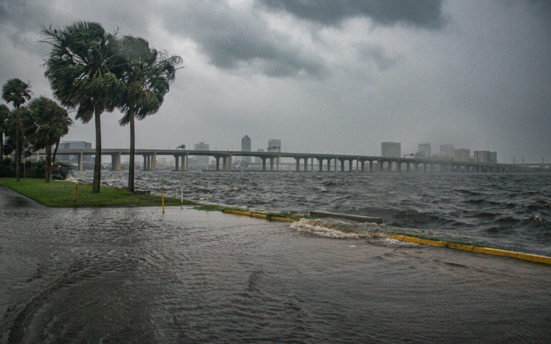
Storm Surge at Memorial Park in Jacksonville after Hurricane Helene (September 2024) – Photo by Will Misner
Beyond the Shoreline: The Widening Reach of Hurricanes
Climate change is amplifying the impacts of hurricanes in the United States. Warmer air and sea temperatures strengthen storm wind speeds while simultaneously slowing the steering winds that would typically hasten a storm’s forward motion; this means that our cities are hit both harder and for longer periods. Rising sea levels, which are predicted to worsen in the coming decades, also amplify storm impacts. Coastal regions are particularly vulnerable, as rising seas increase the risk of tidal flooding, storm surge, and erosion. In recent years, sea level rise has intensified the damage caused by several major storms, compounding their effects on communities and infrastructure. Extreme high tide events, otherwise known as “king tides,” have also increased in duration and intensity due to climate change; as sea levels rise, the time periods when tidal flooding occurs will be similarly heightened. Because the Lower St. Johns River is a broad and shallow tidal estuary, salt water and tides reach as far as 100 miles upriver. Thus, the threat of coastal flooding extends far inland from the Atlantic coastline (Resilient Jacksonville, 2023).
Our low-lying, shallow estuary also means that local areas can remain inundated with above-flood-stage waters for longer periods of time; when Hurricane Milton made landfall in West Central FL in 2024, northern cities in Florida (including Jacksonville) remained flooded for weeks afterward. Likewise, Hurricanes Nicole and Ian caused the St. Johns River to remain above flood stage for 100 days after the storms made landfall.
Human-induced activities are also to blame. For example, dredging can exacerbate the symptoms of sea level rise by amplifying storm surge, increasing flood risk, and contributing to erosional deficits that make entering tidal waters move faster and travel farther.
Beyond Environmental Damage: Monetary Costs of Hurricanes
According to the National Flood Insurance Program, Florida holds the unfortunate distinction of having the highest financial losses associated with flooding in the entire country. Florida also has one of the highest average flood insurance premiums at $829.00 per year. Payments to the National Flood Insurance Program totaled over $1 billion last year.
Here is a more comprehensive damages assessment for large hurricanes that made landfall between 2017-2024:
- Hurricane Milton (2024) Estimated Damage: $30 – $50 billion (insured property) & $1.5–$2.5 billion (agriculture)
- Hurricane Helene (2024) Estimated Damage: > $13.9 billion
- Nicole (2022) Estimated Damage: $481 million (Volusia County only; likely higher statewide)
- Ian (2022) Estimated Damage: ~$109.5 billion
- Irma (2017) Estimated Damage: ~$50 billion (including $2.5 billion agriculture)
Flood Risk
 The Flood Risk, St. Johns River Watershed map to the right shows census tracts in the St. Johns River watershed with greater than a 75% chance of flood risk, using exposure to 100-year flood levels. The percentile is relative to all other census tracts in the United States. This map was created using data from First Street Foundation.
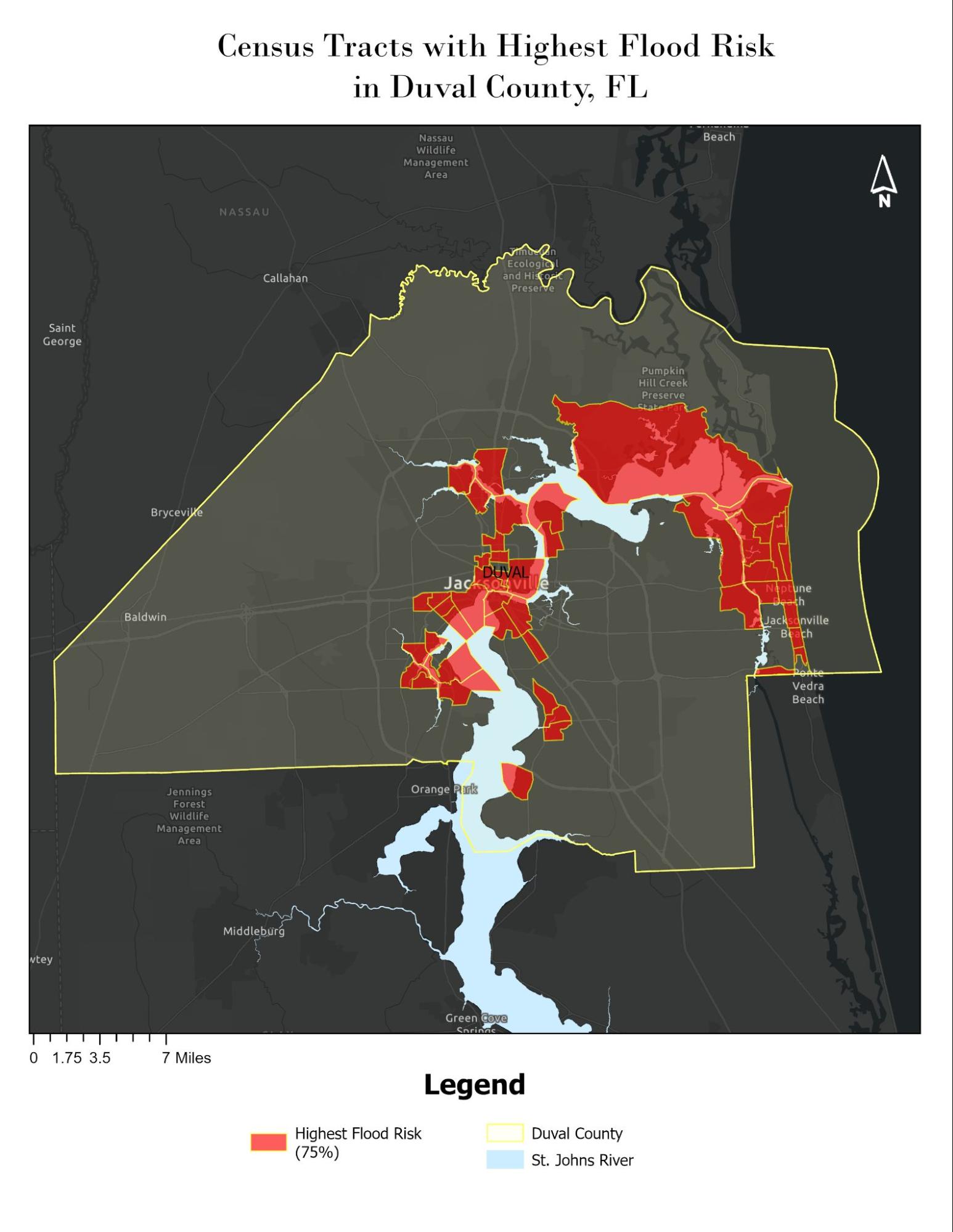
The Duval Flood Risk map below shows census tracts in Duval County with greater than a 75% chance of flood risk, using exposure to 100-year flood levels. The percentile is relative to all other census tracts in the United States. This map was created using data from First Street Foundation.
Storm Preparedness for Your Family
As we continue to traverse prime hurricane season, it is critical that we all take steps to protect our families, our homes, and our businesses. We encourage you to search for the emergency management department or hurricane preparedness website page for your county (Duval, Clay, Putnam, St. Johns, Volusia, Marion, Orange, Indian River).
 Tributary and River Health in Your Neighborhood
It is also important that we protect our river and its tributaries from unnecessary harm.
Here are simple river-friendly tips to add to your hurricane preparedness check list:
- Secure any chemicals, fertilizers or pesticides in your garage or shed in an elevated position that is not subject to flooding, so they cannot leak into our storm drains and waterways.
- Make sure storm drains around your home are clear of debris.
- Avoid walking through moving water and do not let kids play in flood waters after the storm. Flood waters are often highly contaminated with raw sewage, toxic chemicals, and other hazards.
These simple measures will help prevent future harmful algae outbreaks by reducing nutrient pollution in our waterways. If you don’t already know, check out your favorite Maps app to find the closest waterway to your house. You may have a small creek that stormwater around your house leads to, which flows into a larger waterway and eventually the St. Johns River! You can help bolster the health of the St. Johns with simple river-friendly actions around your own home.